Thursday, January 30, 2014

Tunnel Beach

We took another trip to Dunedin not too long ago to visit our friends Martin and Linda.  Martin helped train us when we first arrived in New Zealand, and helped us get used to the new system.  They always find cool stuff to show us whenever we make it up that way. 

We went downtown to check out the farmers market at the Dunedin Railway Station.  Large towers gave it a classic look.  There were bagpipers and hippies around playing all sorts of music.  It was a fun morning.

The market was hectic, lots of vendors with lots of fresh produce.  Too bad we were several hours from home and had a full day in Dunedin still or we would have stocked up!

You could see the Cadbury chocolate factory from the train station, home of the "infamous" chocolate waterfalls. Apparently they are less than thrilling, we won't be paying for the tour.  :)  Their chocolate is tasty though...

Just down the street was an old prison.  Even there jail looks fancy.

After a little time in the city we went down to Tunnel Beach.  It was a long steep hike down the hill to get there, I'm sure it was over a mile down. Felt good going down, but we knew we were going to pay for it coming back out.  The view was great from up high, grass covered sheer cliff formations.

The main "tunnel" of Tunnel Beach.  There are people out there walking on it to give you scale.  The waves broke through the tunnel constantly eroding it, the kelp liked the shallow water.

We walked out there and looking back you could see more of the formations.  The rock cleaved itself at perfect angles falling into the see.  I'm sure the geologists among us have an excellent explanation for this...  Kelp swirled in the inlets with squid-like tendrils. 

Was that why it was called Tunnel Beach or was this why?  From the upper level they had carved out a long stairwell to get to the lower beach.  Mildly claustrophobic, but don't worry you won't get lost, just follow Cole's shoes!

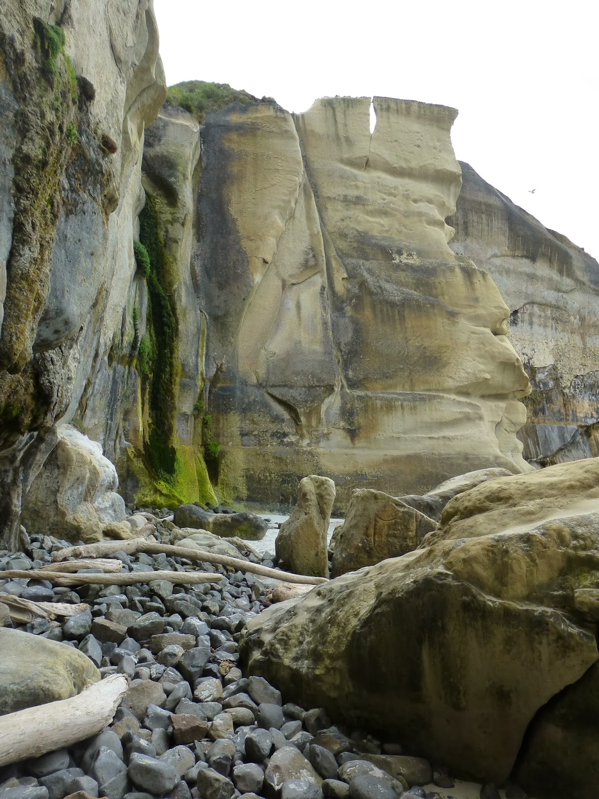
Stepping out on to the rocky shore was like another world with the high sheer cliffs.

The beach had several large boulders that had broken off the cliffs, no half buried jutting out of the sand.

Drainage from the grass above stained the sides of the rocks as it dripped to the sea leaving green and copper streaks.

Like always, the weather fluctuated, when the wind kicked up the surf became powerful.

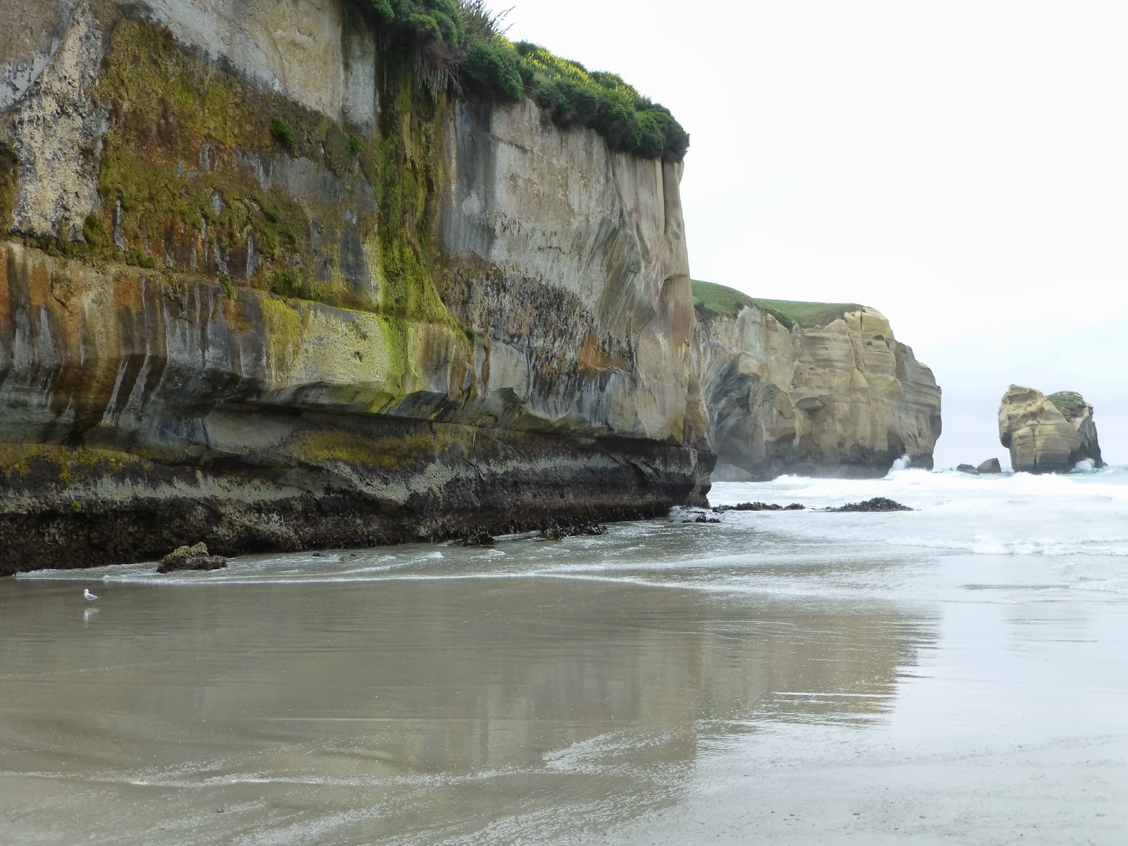
This is what the "main" tunnel beach rock looked like from the lower beach.  Like some great sarcophagus... 
If you look closely you can see the tide wearing away the base of the rock undermining it, eventually I'm sure it will fall like many of the others.


Back up the staircase to greener pastures!

A literal light at the end of the tunnel... man I'm on fire!

Back on top it is just a grassy knoll, you'd have no idea you were standing on an overhang unless somebody was looking form a distance.

Way out at the very end you could look down at the waves, steadily coming in.  There was something just below the surface causing little whirlpools and vortexes as the waves would go by.  It was very peaceful to sit and watch.

There were flowers coming out of moss where we were sitting.  I swear stuff can grow anywhere here...

There's the Howells and Rebecca enjoying the view...

Little did they know what Cole and I were up to.  We found some hand holds heading down the cliff edge.  Cole climbed down towards the water...  Don't worry, I was there to document whatever was going to happen...  He came up without a scratch.

One last look at the relentless waves pounding the rocks before the long, steep hike back to the car.  I wonder how long it will be before this wonder is completely eroded...

The slow march out was such a grind.  Steep and just didn't stop all the way up.  Half way up though we were greeted by a yellowhammer bird resting on a fence post, encouraging us forward....

We made it...  :)

Monday, January 27, 2014

Mount Cook, Chapter 4: Glaciers, Camping and the Mountain Appears!

Cole has had several posts of our trip to Mount Cook already, it was such a crazy weekend.  I thought I'd contribute with a few more pictures.  Its amazing that there is still stuff to tell from that adventure.  It was a very rainy weekend.  We were camping in a campground, the tent section was a large rugged area with lots of growth so we were able to get tucked back into the trees.  It just rained and rained... the tent was so saturated the whole time.

It rained all night both nights that we camped.  The tent gave it the old college try, and it did keep out most of the water, but by the second morning there were puddles by our feet and some of the bedding was wet.

Despite the rain, the scenery was worth it.  This was the view from the tent.  We were sitting pretty far north on Lake Pukaki, about 10 minutes from Mt Cook park. 

Like everywhere else in NZ, raining one minute, perfect blue skies the next.

Lake Pukaki is formed by glacial melt, so it is very cloudy, silty water.  It gives the lake a magnificent blue color.  More pictures of that later.  We got some great shots when we went over to Lake Tekapo on our second day.

We headed north into the park.  Rain was coming and going all the time.  The meadows were flat until it reached the base of the mountains where the would rise upward steeply. 

Woe-is-us... the rain continued so we retreated indoors to the museums and what not at Mt Cook National Park.

There was a cool stained glass exhibit.  We took a picture of one with our favorite NZ bird, the kaka.

Cole, enjoying the view, waiting out the rain.

Looking up the mountain sides from the lodge, it looked like snow was constantly slipping down.  Wouldn't want to be standing up there.

The rain let up! (for like an hour..) so we headed out towards Tasman lake and glacier.  We drove up a hillside, and this was a view back down the valley.  They are constructing a new road down by the river in the picture.


Fresh snow on the mountains making new waterfalls all around.


At the end of the road, there was a rocky climb to get to a viewing point for the glaciers looking back you could see all the rocky rubble and the "blue lakes" in the distance.

According to the brochure, these were called the blue lakes because they were intensely blue... Maybe more appropriately "green ponds."

From the top you could really see back down the valley.  That's the Tasman river winding down there.

Looking down at Tasman lake, it is made up of glacier melt, often full of little icebergs breaking off the glacier.  The water was milky from all the silt from the glacier.  The glacier used to be much bigger and has decreased over the past 10,000 years or so.  You can see all the gravel around the edges of the lake were the glacier ground the rock into bits.

All the way across the leg you could barely make out the leading edge of the glacier.

Another shot of all the gravel and the milky lake.  Across the lake you can see how high the glacier used to be from where it ground down the rock leaving a large "scar" across the mountains.

When it stopped raining and the clouds cleared a little you could see the muddy glacier snaking its way through the ravine.  You could almost imagine it slowly sliding down the valley.

Looking the other way down Tasman Lake there were a few little icebergs floating along broken off of the main glacier.


That little guy was pretty blue, but they mostly looked dirty.  The water was so strangely colored.  I bet that water is cold.  


Back at camp, packing up on the last day, the clouds finally parted giving us our first glimpses of the magnificent Mount Cook.  I know these are all similar but I couldn't help myself.  Such a stunning peak.

New Year's Eve in Sydney!

Just after Christmas, I got to scoot over to Sydney, Australia, to meet up  with my cousin Annette and her friend Krista, and together we had an amazing trip. One of the highlights was the NYE celebration in Sydney. Sydney has the largest fireworks display in the world. It was incredible.

It only got more and more crowded from here. It looks like a fun party, but eventually it just became a giant sardine can.

There were a ton of designated viewing locations all over the city, but after careful research and planning, we found the ideal viewing spot. We were directly across from the Opera House, right next to the Harbor Bridge (the two highlights of the fireworks display), and had a third main fireworks launch point to our left. Together with 50,000 of our closest new friends, we waited and waited and waited for the fireworks show.

They filled a little of the evening with an airshow, which was fun.

Then this boat came and sprayed water in the water.


The Bridge getting warmed up!

This is a little surreal. The Opera House was lit up, shooting fireworks, then the boats on the harbor had lights all over their masts and bowlines, then there were jet skis zooming around shooting fireworks, and at some point there were little fireworks just floating out there on the water. Pretty cool. the blurry picture just adds to the chaos.

The bridge was the center of the action. It had cartoons and messages going up where the NYE 2013 sign is. It had the official countdown, it had most of the fireworks, and the big support beam on the right of this picture also served as the mens urinal wall - the line for which was WAAAYYY shorter than the port-a-potty lines. sorry girls.

The fireworks were amazing.

They just went on and on.

Most amazing fireworks display in the world, literally. It really looked like the bridge was exploding every 30 seconds. Well done, Sydney. You know how to throw a NYE party, that's for sure.